
https://youtu.be/eu0ldBRG4jY?si=Cbv4aGiCNSDt7ror
2023-11-08 01:50:55
China‘s $62BN Water Transfer Project

China is building the world's largest water diversion project in an effort to quite literally defy nature itself with thousands of kilometers of artificial canals , aqueducts and tunnels that cross literal mountains .
China aims to bring fresh water to its dry industrial population centers in the north .
In this video , we will be taking a closer look at China's controversial South to North water diversion project .
How much it costs , why they are doing it and how exactly it will or will not benefit the Chinese people since ancient times , China has always been both blessed and cursed by its geography .
Thanks to the Yangtze and yellow river systems that flow from west to east .
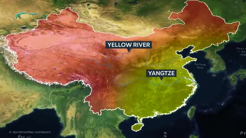
Much of eastern China has always been permanently inhabited by human civilizations for thousands of years and with fertile floodplains almost all year round , the land itself has been able to sustain an ever growing Chinese population .
In fact , China's Yellow River Valley is one of the largest and most consistently developed pieces of arable land in the entire world .
On the other hand , the northern and far western parts of the country are either dry or mountainous from the Tacloban and Gobi deserts in the north to the unforgiving towering landscapes of the Himalayas and the Tibetan plateau .
Most of China's land to the northwest is sparsely populated and unsuitable for agriculture .
This is perfectly highlighted by the fact that 94% of China's population lies east of this line , an imaginary line that divides the country into two contrasting halves .

Historically China's capital , Beijing and its surrounding northern cities have long been a center of population , agriculture and trade for the country .
But as China's population and wealth grew in unprecedented fashion in the middle of the 20th century , resources such as water soon proved to be quite difficult to come across in the region .
Northern cities such as Beijing have long relied on groundwater to sustain their populations .
But because of an ever increasing urban and industrial demand , this limited source of fresh water soon became overexploited .
It also didn't help that the nearby Gobi Desert has continuously been expanding along with more frequent dust and sand storms .
At least 409 million people in China have been affected by a severe sandstorm that's hit the country from Monday .

Now this is northern China is experiencing the highest number of sandstorms in a decade as much as 3600 square kilometers or about twice the size of Luxembourg of grasslands is being reclaimed by the desert every year .
In a process known as desertification , this desertification is mainly caused by human activities such as deforestation , climate change and of course , the aforementioned depletion of underground water sources by the early 19 fifties , it became more evident that northern China would soon be unable to supply enough water to its population .
Northern cities kept growing and water resources kept dwindling .
China had to think of a way to somehow sustain hundreds of millions of people in an area that is historically been dry in order to combat the emerging water shortage in northern China .
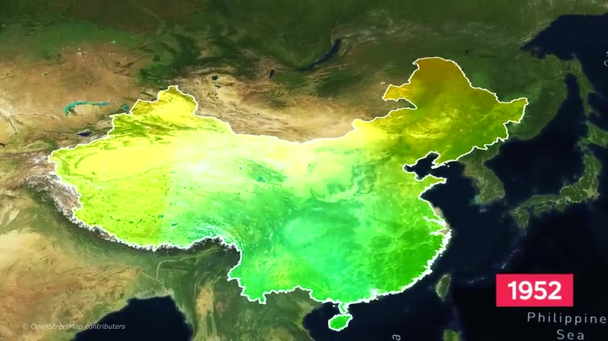
Mao Zedong , the founder of the People's Republic of China proposed in 1952 the idea of simply transferring water from the south of the country to its dry northern regions .
He was quoted as saying , water in the south is abundant water in the north is scarce .
If possible , it would be fine to borrow a little 50 years later .
In 2002 , Mao's vision was finally approved by the Country's State Council .
After years of extensive planning and research , the mega project would officially be called the South North water transfer project .
An ambitious plan to create a series of connected aqueducts , tunnels , reservoirs and dams that would transfer fresh water from the water abundant south to the water starved north .
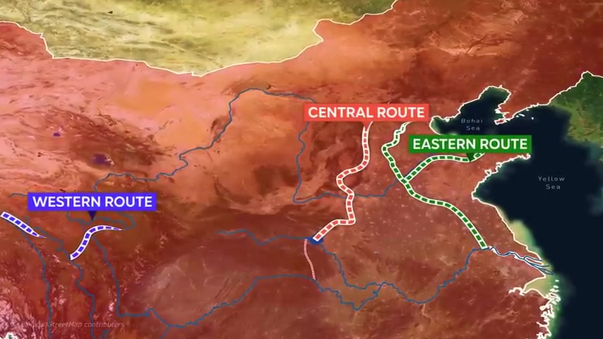
The project would consist of three major canal systems that would be called the eastern central and western routes .
The eastern route begins near the city of Yangzhou through a major branch of the Yangtze River .

A massive but old pumping station is responsible for pumping the water from the Yangtze into the Jing Han Grand Canal .
The world's longest artificial waterway from there .
The water passes through an underground tunnel , bringing it across the Yellow River .
Finally , a series of aqueducts transfers the water towards the coastal city of Tianjin which borders the capital Beijing to the northwest .
In total , the entire stretch of the project's eastern route is over 1100 kilometers long .
Construction on the eastern route began in 2002 and was expected to carry fresh water by as early as 2013 .
However , due to multiple delays in the construction , this was pushed back by over four years .
As of 2017 , freshwater has finally reached Tianjin with an estimated volume of 1 billion cubic meters of water per year which directly benefits as many as 10 million people in the city .
Unlike the eastern route of this mega project , the central route didn't already have pre existing infrastructure that it could divert water into because of this construction on this route was significantly more challenging .
The central route begins in the Danjiangkou reservoir .
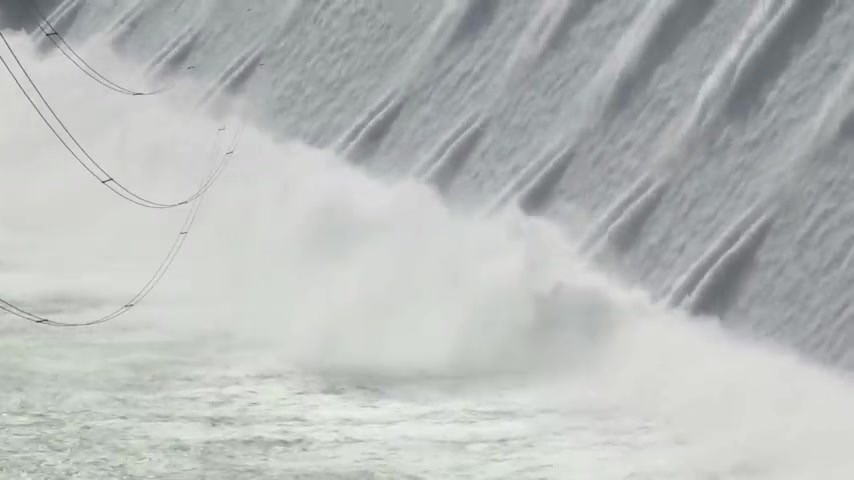
In order for the water to easily flow downstream towards the north , the Danjiangkou Dam had to be elevated by as much as 15 m .
This the water inside the reservoir to increase high enough so that the water can travel through the canals and aqueducts without having the need for pumping stations .
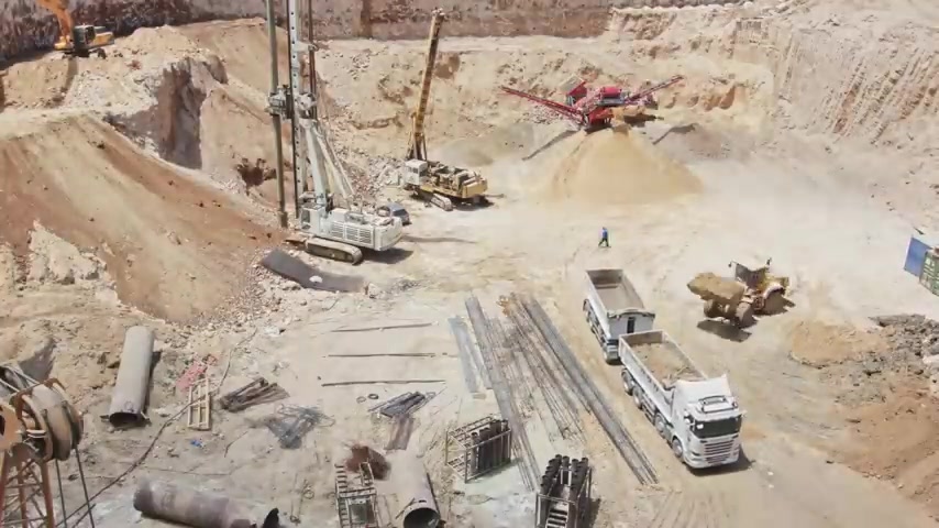
However , because of these changes to the Danjiangkou dam , more than 300,000 people had to be relocated away from their homes to give way to the canals and the larger reservoir .
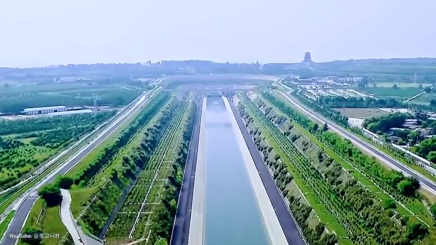
The rest of the central route is made up of manmade canals and aqueducts that form a sort of high of elevated and underground waterways spanning the Chinese central plain .
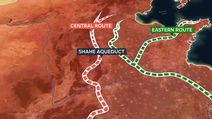
One notable part of the central route is the Shahe aqueduct that stretches over the Shahe River above the ground for over 12 kilometers .
Finally , the central route reaches its destination Beijing , the nation's capital , the central route finished construction in 2014 and is over 1200 kilometers in length .
Following its completion , approximately one third of all the water that flowed through the Han River was diverted .
This posed significant problems for the millions of people that relied on the Han for fresh water .
So in July 2022 the Chinese government announced that they were building a massive underground tunnel that would supply the necessary water .
This tunnel would run one kilometer below the surface and connect the three Gorges dam to the Han River and even to the central route all the way up to Beijing .
Once completed , this tunnel would become the longest and deepest artificial waterway ever built by 2030 .
The central route is expected to transfer as much as 12 cubic kilometers of water annually or roughly a third of the entire capacity of the Three Gorges reservoir .
Unlike the two previous routes , the western route of China's South North water transfer project is still in its planning stage .
Among the three , it is by far the most challenging one to construct the proposed plan for the western route is to create a series of waterways and tunnels that would connect the Yangtze River to the Yellow River .
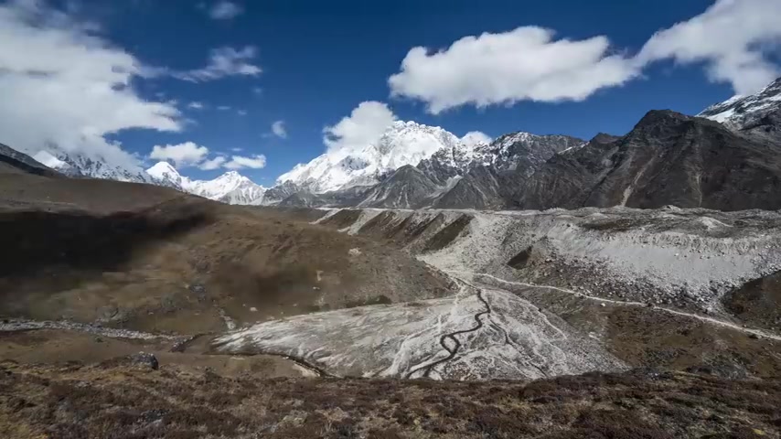
The Qinghai Tibet plateau which is approximately 3 to 5 kilometers above sea level .
The area's topography and climate alone make it extremely difficult to undertake this project .
In addition , the western route's direction would require engineers to literally carve mountains in order to cross the tricky terrain .
The western route is estimated to be completed by the year 2050 .
If the western route was to be completed , it could serve a combined population of nearly 100 million people .

There have also been unofficial plans in the past for the western route to divert water from trans boundary rivers that originate from China such as the Brahma Hra and Mekong rivers that pass through India and Southeast Asia respectively .
Although this has never been the official plan for the project .
India has raised concern in the past over China's possible exploits on the Brahmaputra .
They worried that China's ability to manipulate the river's flow is a cause for concern for the Indian government , for the Chinese government .
On the other hand , the South North water transfer project , even though it has not been fully completed is already proving to be a huge success .
According to the Chinese state media , the project benefits as much as 140 million Chinese citizens in water starved regions .
However , local and provincial Chinese governments all have different opinions on the project .
For one southern upstream provinces such as Sichuan and Hubei are opposed to the plan of redirecting the Yangtze's flow to the north for them .
The construction of the project's western route would be a big blow to the region's water security and hydropower sector .
On the other hand , Western provinces like Gansu and Qinghai believe that the construction of the western route would bring much needed socio-economic and agricultural stability to their regions .
Although the project may have proven to be beneficial to some Chinese cities in the north .
The South north water transfer project has raised plenty of concern from local and international environmentalists .
The project in its entirety is made up of artificial waterways that do not conform to the natural west to east flow of China's rivers because of this hundreds of natural rivers have been interrupted by the canal's construction and some have even completely dried up as their natural flow has been artificially diverted .
In fact , because of the sheer size and volume of water being carried by the water transfer project , 600 rivers have already disappeared over the course of the project's construction .
Additionally , industrial waste and sewage have inadvertently made their way to these artificial rivers on the central route , for example , which begins at the Dan Jiang Kao reservoir .
Industrial cities such as Xi'an dump , their industrial waste into the Han River which feeds directly into the reservoir and eventually to the central route that leads up to Beijing .
Since a large portion of these artificial rivers go through hundreds of cities and villages across the country , many people , businesses and industries dump their trash into these manmade waterways .
When the Yangtze's natural flow was cut short by as much as 36% during the opening of the project's central route .
Experts feared that there could be a significant backflow of sea water from the Yellow Sea and onto the local water supplies of coastal Chinese cities .
If the Yangtze's flow continued to decrease as more water got diverted into artificial rivers , salt water from the Yellow Sea could even reach as far back as the man made canals themselves .
If such an event were to occur , it could trigger a water crisis across the entire country .
Another environmental concern is one of the main reasons as to why the western route has been stuck in the planning stage for a long time .
Now , the official plan for the western route involves the creation of tunnels that pass through an extremely mountainous region of China .
The construction of the western route could potentially trigger landslides and environmental destruction to the local flora and fauna .
Additionally , the Qinghai Tibet plateau is a seismically active region .
Constructing a vital mega project along this area could potentially cost the Chinese government billions of dollars if ever a major earthquake were to go off in the region today .
The North South water transfer project has completed two out of its three planned routes in total .
The entire project's cost is estimated to be around $62 billion .
This price tag doesn't even account for the billions of dollars .

The Chinese government would soon need in order to maintain more than 3000 kilometers of canals , aqueducts , dams , tunnels and reservoirs .
Despite this high financial cost , the project's original goal of supplying clean water to China's North is yet to be fully realized .
So what are your thoughts about the South North water transfer project ?
Do you think the benefits of the project outweigh its environmental costs ?
Should the western route still be constructed ?
Let us know in the comments below .
If you want to learn more about similar mega projects , you can check out our video about the biggest mega projects in the world .
Thank you for watching and we'll see you in the next video .
Partnership
Are you looking for a way to reach a wider audience and get more views on your videos?
Our innovative video to text transcribing service can help you do just that.
We provide accurate transcriptions of your videos along with visual content that will help you attract new viewers and keep them engaged. Plus, our data analytics and ad campaign tools can help you monetize your content and maximize your revenue.
Let's partner up and take your video content to the next level!
Contact us today to learn more.